Do residents have the right to pass freely on those roads?
Residents who’ve lived in the area for a while may remember ….. nine years ago (?) Thames Water carried out major works in Devonshire Road at the junction with A205. The road was properly blocked - not plastic barriers that people get out of their cars and push out of the way.
The change to quality of life was extraordinary: more relaxed, more conversations between neighbours, quality of sleep improved, safer for cycles and skateboards etc etc. We had about six weeks of peace before the aggressive noisy commuter traffic was switched back on.
3 Likes
Thank you everyone for the suggestions in this thread! As Jonathan mentioned, tackling the traffic issues on Devonshire Road is going to be one of the major priorities for myself and Annabelle as newly-elected councillors for Forest Hill.
I am currently putting in a request to the relevant council officers for a full run-down of any previous exploratory work done (including historic resident consultations) to address this issue under the previous council administration. Until I’ve done a bit more fact-finding, I’m hesitant to commit to a particular solution here - but it seems to me that we ought to be considering both potential “quick fixes” (e.g., removing a small number of parking spaces at the Waldram Crescent end of the road to prevent the bottlenecks that form there) as well as longer-term structural rethinks of traffic flows in this area.
I’m aware that there are roads in Southwark that have experienced similar issues - so I’m also keen to see if there are any learnings we can take from their experiences. As alluded to in this thread, we may also be able to use residents’ experiences when diversions were in place due to roadworks as an additional data point to help speed up the process of identifying a permanent solution. I’m also conscious of the fact that whatever solution we do find will need to be understood holistically in the context of Forest Hill traffic flows; we don’t want it to have negative knock-on effects on adjoining roads or roads like Honor Oak Road that drivers might use as an alternative to Devonshire.
Annabelle and I have only been in office for a few days at this point, so please bare with us while we’re still acquainting ourselves with council procedures and systems - but I hope to have a more concrete update to share with you all soon on this issue!
5 Likes
In Dulwich’s case where they set up two LTN’s in the Village and East Dulwich at the same time, East Dulwich Grove has seen the worst of the traffic especially around school time as there’s a mix of independent schools and the newish Charter School Academy, while Lordship Lane has traffic issues at the retail end of the road and waiting traffic to turn right into Dulwich Common sometimes backing up to the library.
Their closures are a lot more ambitious that what is being proposed here, they introduced a bus gate on the main Dulwich Village road, stopped cars going through Townley Road during school dropping off times, blocked off Court Lane and introduced road closures in Melbourne Grove and the side streets off Grove Vale.
It may be worth suggesting a bus gate for Honor Oak Road during school dropping off and picking up times which would allow the P4 to use the road normally as now, but it would increase traffic between the town centre and the northern end of Devonshire Road via Stanstead Road and Brockley Rise. However the P4 bus reliability isn’t great because of the extra trafic using Dulwich Common. There’s so many variables to consider!
The idea that Thorpewood Avenue was a major rat run appears weakly supported by the available evidence.
Historically, the more obvious issues were parking pressures: Eliot Bank school drop-off/pick-up at the Kirkdale end, and all-day commuter / visitor parking associated with the pools, library and station at the Dartmouth end.
Before 2020, the discussion appeared to focus on parking issues on Thorpewood and traffic concerns around Devonshire Road. A school street proposal for Thorpewood had broad support, though many residents wanted both schools included, particularly Holy Trinity at the busier junction.
Instead, a permanent westbound barrier was introduced, in addition to the two-hour timed school restriction at Kirkdale, with limited consultation.
The council’s own pre-implementation westbound traffic count, taken outside Eliot Bank for one week rather than at the busier Holy Trinity end, showed:
-
Sunday: 188
-
Saturday: 255
-
Weekdays: 406–438
-
Peak hour: 76 (AM)
-
Afternoon peak: ~60
These are not the kind of figures most people would associate with a severe rat run, especially given the obvious school-run effect in the peak hours. A significant proportion appears to be local and school-related traffic.
If residents living on roads below the barrier previously used Kirkdale to head west, the barrier simply forces those same journeys to exit via the Holy Trinity end instead, adding roughly a 1km detour for some local trips.
That may be a worthwhile trade-off for residents within the filtered section, but it also means some traffic is displaced onto neighbouring roads rather than removed altogether. Meanwhile, the all-day commuter / visitor parking pressures associated with the pools, library and station, one of the original issues residents experienced remained largely unaddressed.
By comparison, Devonshire Road ULEZ ANPR data shows around 4,800 daily vehicle movements, with a peak hourly count of 396. Even allowing for differences in measurement method, Devonshire appears to operate at a vastly higher traffic intensity and shows much stronger through-traffic characteristics.
That makes the contrast difficult to ignore: the stronger anti-rat-run intervention was applied to the quieter end of a residential street with one school, while the much busier corridor remained open.
As to what should happen with Devonshire, the sensible approach is to start with evidence, agree what problem is actually being solved, and then choose the intervention accordingly.
6 Likes
That sounds reasonable, except that many of us suspect that previous decisions may have been taken irrespective of evidence. I hope that the new administration looks at historic decisions as well as the current situation - which should not be regarded as set in stone and irrevocable.
What has been the criteria used for selecting streets for traffic calming and Low Traffic Neighbourhoods? I have asked but never given a straight answer by Lewisham Highways or Councillors (previous regime), which tells me that the decisions were political and not based on objective transparent application of criteria to data.
Have had this thought also, could be gated with key lock for emergency vehicle access.
Only downside I see is that some would still use routes to try and cut corners, eg up Boveney/Hengrave to Honor Oak Road.
Access for emergency vehicles is no longer an issue when closing off roads to thru traffic. Cameras can be used rather than physical barriers - like the scheme for Silverdale and Bishopsthorpe.
If both ends of Devonshire were closed, Boveney/Hengrave would not become rat runs.
2 Likes
Can someone please find a solution to the traffic gridlock on Devonshire Road? It’s 10:05pm and we now have horns blaring, tempers, and vehicles unable to move either way at the Honor Oak end.
Last year, my car was just about totalled in a hit and run which was a £3500 repair job. I’m now in favour of closing it off at both ends.
1 Like
I remember the first time we visited Devonshire Road to look at the house we now live in, back in 2014, there was total gridlock at the Honor Oak end of the road, which necessitated someone (me!) getting out of the car, and literally walking up and down that narrow stretch of road using hand signals to get people to back out in order to untangle the mess.
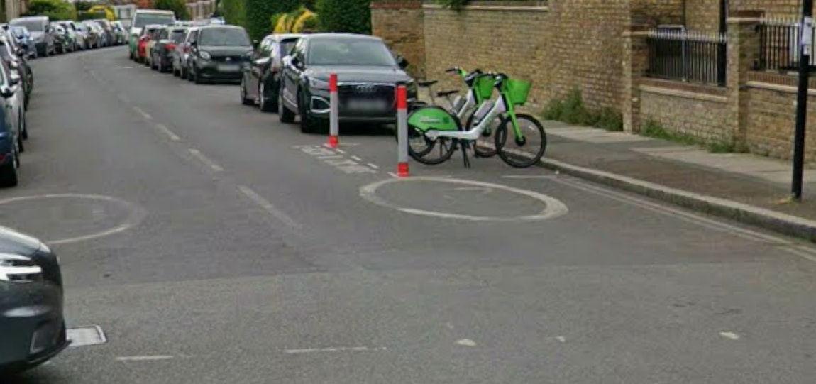
I have to say though that I’ve seen more of that particular problem since the red and white traffic pole to delineate a rental bike parking area right at the Honor Oak Park junction was installed, which makes it very difficult for two cars to pass right at the end of Devonshire Road.
I know we’ve discussed simple fixes that would mitigate these issues in the past, and they have been somewhat frowned upon, but while some sort of closure of the road to traffic other than for residents is considered, I do think extending the corner double yellows by one or two parking spots, and moving the rental bike parking spot a space or two further along could make a big difference in terms of mitigating the issue.
Flagging this to the @FHCllrs who have previously commented on this issue.
2 Likes
It’s easy to conflate the two issues of (1) excessive volume of traffic (2) gridlock.
Commuter traffic is purely concerned with the latter; there is no concern about degradation of the quality of life which comes with high volume of traffic. Dealing with (1) will solve (2), but facilitating faster easier flow of motor traffic won’t improve the environment for residents - except those who prioritise their motoring life above all else.
1 Like