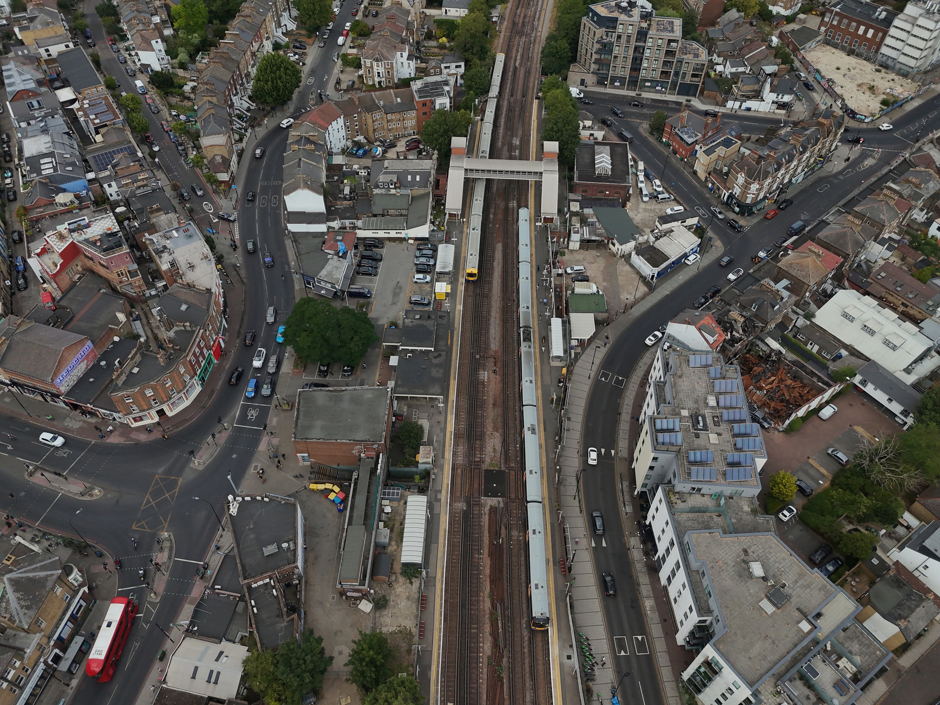
Sorry, another drone shot. The main routes that all come together at the pinch point of the railway bridge. Always interesting watching how all the traffic merges and moves from all the surrounding roads. Timelapse next time maybe? 
6 Likes
I did a little timelapse from another angle
Fifteen minutes above Forest Hill. Amazing how many trains come and go, and seeing the traffic flowing around.
Will be curious to do this again when the schools are back at rush hour. Very different scene I imagine.
2 Likes
There’s no avoiding the fact that the ‘town centre’ design we have now, functions primarily to facilitate the flow of road traffic through the area.
Fascinating Snazy!
Thank you.
Funnily enough, I was struck by the still shot by the ‘wrong’ utilisation of space and buildings in the centre AND my bugbear virtually non-existent pedestrian flow alongside the betting office at the start of Dartmouth Road, but watching the traffic was amazing.
I’d be interested to see, if someone’s clever with AI and could ask it to model a solution to our traffic and pedestrian conundrums after uploading your video, what it would come up with.
1 Like
It’s all very disjointed isn’t it. Functions surprisingly well given being all over the place. Not really much that could change that.
Kinda highlights both the history of the roads and the lack of something functional at the centre (hub)
Glad it was interesting and informative. I think the biggest problem for traffic flow is it’s not tidal as such. But erratic depending on a number of factors.
High residential density with lots of vehicle journeys starting and ending in the area. A main arterial road carrying transient traffic through the area. A large number of schools adding to the traffic load twice a day. Businesses with deliveries regularly blocking a lane at unscheduled times, and so much more.
The right turn into Devonshire is a large contributing factor, the turn right into London Rd with immediate 2 into 1 creates a bottle neck also. Under the bridge going into 2 lanes for mainly no other reason than to soon return to 1 Lane (with exception to traffic turning into Devonshire and straight on to Dartmouth) for the majority of the transient traffic.
Generally I think the traffic does well, but is regularly a victim of roadworks and other incidents on the outskirts.
And also because of the number of roads feeding into the South Circ at almost the same point. Within 200 metres or so you have Westbourne, Perry Vale, Waldram Place, Devonshire Rd, and Dartmouth Rd all all feeding in and out. And the 2 points where the road widens then narrows again.
In short, it’s too unpredictable to create something that works at all times of day.
2 Likes
Continuing the analogy of the beating heart, this is a distressed heart in need of a double bypass and pacemaker.
People keep telling me that it’s unrealistic, but I can’t see any option other than a tunnel: either a short one from the junction of Stanstead/A205 (between the storage company, Railway Telegraph, ex-garden centre premises) to the Grove Tavern (junction of Lordship Lane and A205), or a major arterial project for the South/North circulars.
There’s loads of tunnelling going on; why not here?
We’ll see what the town planners, architects, engineers etc come up with. I’m keen to hear what Rob (FHS Chair) can tell us after upcoming meetings with the Council and other interested parties.
1 Like
I think the biggest issue is the run up to and from a tunnel, where would it practically start to dive, under what properties, to what depth etc. You probably need a good 1/8 - 1/4 of a mile run up to it and away from it. Look at something like the Rotherhithe Tunnel for example, and that goes under almost nothing (but the River Thames) Utilities, homes, businesses. Years and years of disruption.
Is it worth it. And what would the cost be?
2 Likes
There is really zero point discussing a road tunnel option - it will never happen for all sorts of logistical, political, environmental and practical reasons. If it were to be approved, by the time it is built and operational, we’d either be more focused surviving the climate change impacts created by the ongoing reliance on car traffic (this is particularly evident this year), or we would no longer need it as we would have found suitable alternatives to the private car and so traffic will be reduced and no tunnel would be required.
The Society does have a plan that will improve many aspects of this, but I am not in a position to share this quite yet as we are still working on it and getting input and support from Lewisham Council and others. As soon as we can, we will share more information, of course.
Hearing more thoughts on the key issues, and possible (practical) ideas for solutions, could help as it could feed into our plans, … but these will not include a tunnel.
3 Likes
I was thinking the other evening, and wondered what would occur if the following was implemented.
No right turn from South Circ to Devonshire Rd, No right turn from Devonshire to South Circ.
As road splits under the bridge by the mural. Right lane straight on then turn right to London Rd only. Left lane straight on only to Dartmouth Rd (except buses) Only 122 to stop at stop outside station to reduce left lane delays due to buses stopping.
That is pretty much what we proposed when we met with Lewisham a few years ago (which they liked, but then told us that Forest Hill changes were not a priority).
Most of this is a combination of Lewisham and TfL to manage, so not simple to make it happen, but there’s a definite logic to it.
We’re hoping to present this again to the new administration at some stage, but it will be a part of the overall proposals we are making in the area.
1 Like
Wow, seems my thinking isn’t so out there after all. Every plan and change will of course have an impact on surrounding roads, but hopefully this would also address the Devonshire bottleneck and pinch point too. Now of we could just make safe passage for cyclists from the rail bridge to outside the station, all my dreams will have come true 
Hoping to do a school holidays rush hour timelapse and then another when the schools are back to see how things change. Just out of curiosity to see which parts impact the flow the most.
2 Likes
There are some extraordinarily dangerous crossings for pedestrians in the area. Incredible that they’ve been allowed to continue unregulated. Some examples: Waldram Place at both ends; Honor Oak Road at the junction with London Road - this one is a main walking route to the Horniman; hundreds of children use this every day.
3 Likes
IMHO these are symptoms. The problem is the high volume of traffic. If we make the traffic flow better for commuters driving through the area, how does that benefit residents? It would simply draw more traffic to the locality.
1 Like
I guess you have to decide what the goal is. Free moving traffic or at least not sitting idling traffic. Less traffic, but I don’t see how that is possible in reality. Sometimes free moving traffic is safer as there is less frustration.
There is of course the behaviour of pedestrians also. Not to mention the impact of school run traffic too. Every summer holidays the road calm down and feel somewhat more friendly.
Maybe minimising school run traffic, encouraging use of local schools, public transport and maybe even a school bus system. Sometimes the answers aren’t the easy ones or the popular ones.
Re the original point, the bottleneck is caused by a multitude of factors, from traffic volume, to road planning and in some cases deliberate meddling with it to create negative feelings.
For example the scheme in Manor Mount, or this one in Silverdale.
There are lots of traffic reducing arrangements in Lewisham and across London.
I’m not saying it’s not possible to reduce traffic on certain roads. But that simply displaces it, not remove or reduce it. Some of the schemes are practical and serve a purpose, others just displace it seemingly for the sake of causing chaos.
2 Likes
I agree with the point about displacement. Traffic displacement policies simply create borders, those inside benefiting while those outside absorb the displaced traffic, without really making a difference to the actual amount of traffic.
I think you need to work out what the requirements are and prioritise them.
-
Cars / South Circular traffic. Keep the South Circular flowing. I would guess around 80% is through traffic, with perhaps 20% going in or out of Dartmouth Road.
-
Pedestrians. There are essentially three crossing routes and at the moment they all take two stages. I would guess roughly:
70% Station to London Road, Sainsbury’s side
20% across London Road, Costa to Sainsbury’s side
10% across Dartmouth Road
- Buses. How do we keep them flowing and stop them backing up? Dartmouth Road can be particularly bad, with walking sometimes quicker than the bus between the library and the Capitol.
Something has to be prioritised. Looking at the above, I would give priority to the Station to London Road pedestrian crossing and let people wait a little longer on the other sides. Could that become a single crossing rather than the current two-stage crossing?
There would probably be a knock-on effect on Dartmouth Road, and it might be worth considering making the exit from Dartmouth Road onto the South Circular bus-only, while leaving traffic entering Dartmouth Road from the South Circular as it is.
Dartmouth Road contributes a lot to Forest Hill and has come a long way since the road improvements made it much more pedestrian friendly. We now need to make it more bus friendly too.
1 Like
Very nicely summarised 
We should abandon the idea of the south circular as a orbital road that needs to be given priority over local traffic. The fact that it have existed for 90 years without a bus that follows the route should tell us all we need to know about it - it serves little practical purpose.
I’m not saying the road should be closed, just that it should not be prioritised above all other routes when most journeys in London continue to be radial rather than orbital. The road itself goes from nowhere important (Woolwich Ferry) to some else unimportant (Kew Bridge). From Forest Hill it is usually faster to get to the Blackwall Tunnel by going through Deptford and it is faster to get to Heathrow via Hammersmith rather than Kew. The road itself has a 20mph speed limit (much lower than it’s northern counterpart) and there is a good reason for that - it cuts through major town centres like Catford Wandsworth, Putney and Forest Hill.
And when it is closed due to burst sewage pipes or similar, the whole of South London doesn’t grind to a halt, so those few seconds saved by not stopping the traffic to allow pedestrians to cross in one go would not bring about the end of civilisation south of the river.
My proposal, following that diatribe, is that pedestrians are given an opportunity to cross the road in one go, rather than waiting for the convenience of cars.
I would also recommend the removal of the barriers outside William Hill to provide a few centimeters wider pavement at this point and move the lamppost out of the way. This might allow people to pass each other on this stretch of pavement rather than having to give way to pedestrians approaching from the other direction.
6 Likes